Pennsylvania Water Science Center
Estimates of Mean-Monthly & Annual Ground-Water RechargeSulphur Springs Creek near Manns Choice: 01559700 |
| Graphs | Data Tables | Detailed Station Information | Land Use Map | Geology Map | Back to county map | Back to state map | Main Page |
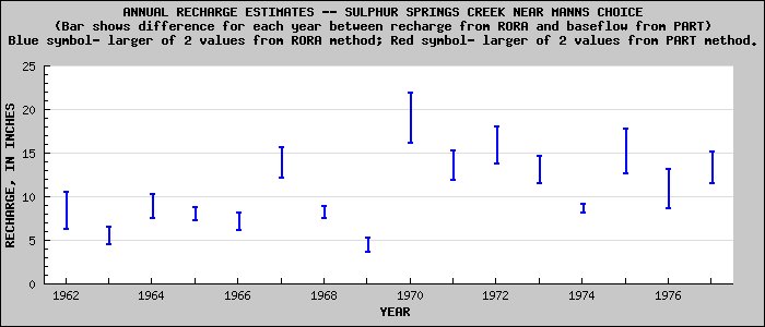
From Recession Curve Displacement (RORA) Method | 12.5 |
From Hydrograph Separation of Baseflow (PART) Method | 9.4 |
Drainage Area (square miles) | 5.3 |
Period of Record Used for Estimating Recharge (calendar year) | 1962-1977 |
Land Cover (show map) (Forest/Agriculture/Developed/Other) as % of Area | 80.6/19.3/0/0.1 |
Rock Types (show map) (Sandstone and Shale/Carbonate/Crystalline/Unconsolidated Sediments) as % of Area | 98.3/1.7/0/0 |
Graphs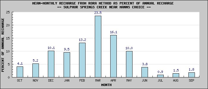 |
 |

![]() U.S. Department of the Interior |
U.S. Geological Survey
U.S. Department of the Interior |
U.S. Geological Survey
URL: http://pa.water.usgs.gov/apps/recharge/station_graphs/01559700_graphs.html
Page Contact Information: Pennsylvania WSC Webmaster
Page Last Modified: Thursday, 10-Feb-2011 22:02:39 EST

